A day with two types of scenery, first the coast path followed the top of the crumbling cliffs, rising and falling into little valleys, later it crossed sand dunes around the seaside town of Porthcawl.
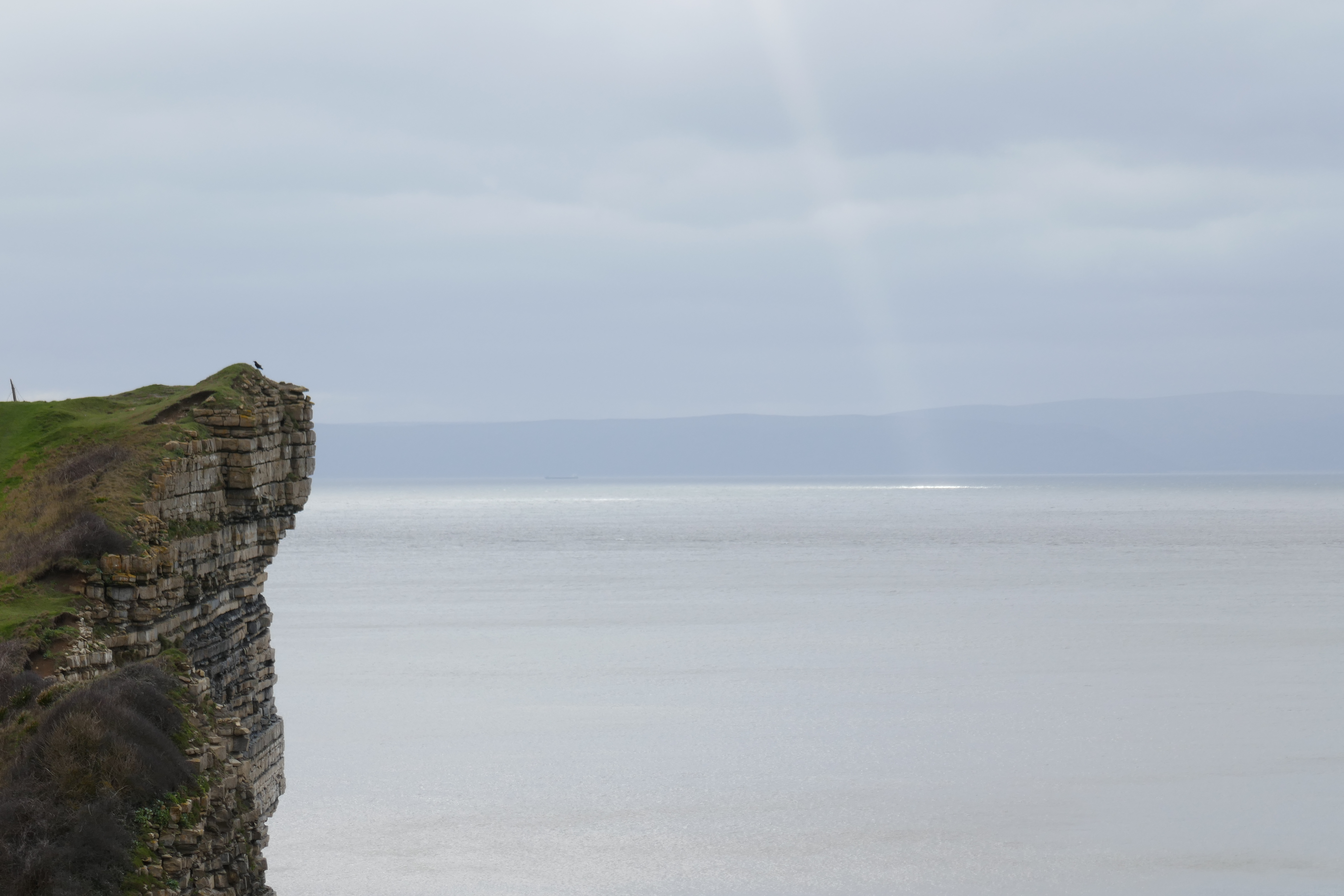
After returning to the stony beach at Llantwit Major, I climbed steps out of the narrow valley, admiring the cliffs on the other side. The path then faithfully followed the edge of the cliffs, close to my left. As they looked pretty unstable, with a few large cracks and landslips, I took care to keep away from their vertical drop. They are made of the Blue Lias, a distinctive rock formation of Jurassic age, composed of alternating layers of grey limestone and shale, the limestone bands around 20 centimetres thick and standing slightly proud, the shale layers a little thinner, slightly darker and more easily eroded. On the foreshore the limestone formed wave cut platforms, like pavements, the smooth grey rock cut by regular joints or cracks. Periodically the path dropped down into a steep sided valley, flanked by slopes covered with low trees and bushes, bare of leaves at this time of year, a few yellow gorse flowers relieving the drab winter colours. I always seem to walk this section in winter, the paths muddy and slippery, the sky overcast, although not without beauty as the sun sent shafts of light through gaps in the clouds. Today I was joined on the trail by dog walkers and elderly couples, all wrapped up against the cold wind.
Interest was added by a number of sites including a few pillboxes from the Second World War designed to defend Britain from invasion. St Donat's Castle was an older fortification, its crenelated battlements now home to Atlantic College where students from around the world study for their International Baccalaureate. Its buildings extend down to a stony beach, I looked in at an opening in the wall, but all was deserted. Dunraven Castle further down the coast is now in ruins, many of the remains are of a Victorian age when there was a romantic interest in Mediaeval structures, but its foundations were much older.
A lighthouse, brilliant white as if in a paint advert, breaks the skyline near the valley at Marcross, an older smaller lighthouse squats nearby. I remembered this section from walks with my parents as a young child, climbing the lighthouse on occasions it was open was particularly exciting, although nowadays, with GPS and ship borne radar, I wonder whether the lighthouse and the huge foghorn nearby has any utility. At the carpark beyond I was blessed with a building selling coffee and Welsh cakes (for the uninitiated the dough, speckled with currents is made into flat, round shapes and cooked on a gridle). Later, after the town of Ogmore I tried a "chimney" cake, which was new to me. A cylindrical tube was made by wrapping a coil of dough around a wooden form, which was then rotated as it cooked above a heating element, the lad at the stall selling them outside the closed "Pelican in its Piety" pub showed me how I could see it being cooked by looking at a specially positioned mirror above. More of a sweetened bread than a cake I had mine wrapped in chocolate powder (which made it a bit too sweet).
 |
| Looking back at the cliffs of Blue Lias on what is known as the Glamorgan Heritage Coast. |
 |
| Marcross Lighthouse and its older, squat colleague to the left |
At Ogmore the Coast Path misses the town (which seems to lack any centre), running through a car park set in a grass covered area cropped by sheep, above the beach distinguished by outcrops of grey Carboniferous limestone. A line of fishermen where casting off from rocks nearby. In their old age, my parents used to come to this car park, and sit watching the sea or reading their library books with sandwiches, a flask of coffee and maybe a hard boiled egg each with some salt and pepper in a twist of aluminium foil. After Ogmore the trail heads inland in order to cross the River Ogmore at a footbridge upstream. I have read that at low tide you can wade across the river close to its mouth, maybe near the sign saying "Danger - No Swimming", but I have never attempted it. A little way upriver are the ruins of Ogmore Castle, beside which are stepping stones for crossing. Today they were under the fast flowing water making the white footbridge further inland, a metal suspension bridge, the only option. All of the paths were muddy today (as they are most of the winter) and the field before the bridge was particularly water soaked and squidgy.
After crossing the River Ogmore and walking by the thatched cottages of the Merthyr Mawr village, I reached the sand dunes of the same name. Hidden among the trees by the entrance car park are the remains of Candelston Castle, a 14th century fortified manor house. After walking through the dunes and following the River Ogmore downstream to its estuary I reached the long beach stretching two or three kilometres towards the town of Porthcawl. Mainly sand with a band of pebbles separating the beach from the sand dunes behind, there was plenty of wood and flotsam washed up. Some kids huddled together at one end of the beach while dog were exercised on the sands. Blue-grey clouds covered most of the sky but the unseen setting sun sent shafts of warm light down to the sea's horizon and coloured sporadic patches of cloud an orange-brown.


As I circumnavigated a holiday park of trailers, their windows dark, and wandered through the town of Porthcawl, the twilight turned to a moonless night. Although I had brought some healthy food (tuna and couscous) for tea, I was tempted by the fish and chip shops. After resisting the attractions of the first three I succumbed at the fourth and enjoyed a generous helping of battered cod and chips in the dark of a shelter provided for visitors, out of the wind by the beach, my head torch proving essential. I then continued on the coast path, sharing the pavement with people out running and dog walkers. Beyond the old Miner's Rest Home, now turned into blocks of luxury apartments, the route follows a boardwalk between the beach and a golf course. A sign stated that the path was closed. Diversions are reported on the Wales Coast Path website, but although I checked I had not spotted this one, maybe it was new. While the notice described a diversion, I did not recognise the street names and it referred to "informal" paths, but gave no clue as to where they went. A map would have been really useful. Sometimes these notices are put up due to maintenance works. At this time of night no-one would be working and if some of the boardwalk was in pieces, I reasoned I could easily divert onto the beach (the tide was out). So having checked there were no river crossings on the route (where a footbridge might be out of action), I walked around the barrier and headed quickly down the path before anyone saw me, my head torch lighting the way. There was no sign of any maintenance activity, and the boardwalk was easy to follow. I have often found that diversion signs are posted for periods well beyond when any maintenance or tree felling works are in progress, I guess it makes it easier for the bureaucrats, who are not accountable for the difficulties they cause, if they were walkers they would surely have posted a map.
After the boardwalk section things were made difficult as I entered the sand dunes of Kenfig burrows, as areas of water reflected what little light came from the sky, appearing as steely grey, mirrored planes of irregular shape among the matt grey-black of the surrounding area. No lakes or ponds were marked on my map, and as the track disappeared into the water I realised they were regions of low lying ground flooded by recent rains. I worked my way around them on the raised area behind the beach but it was hard work in the dark. Time to stop for the night.
I picked a sheltered spot to camp up in a dune among the tussocky grass on apparently flat ground (although during the night I tended to move down the slight slope). During the long days of the Covid 19 lockdown I had bought a bivi bag on-line for no special purpose. I thought it might be useful should I need to camp in an emergency (although I would also need to carry a sleeping bag), or maybe I was just bored. So tonight I decided to try it out. It meant leaving my back pack and boots outside, which I was not entirely happy with. I put them in black plastic rubbish bags to protect them from any rain. Getting my boots off and trousers down, before climbing into my sleeping bag, all without stepping on the damp sand required a good deal of agility, but in time I was cosily tucked into my sleeping bag within my bivi bag, writing up my day by the light of my head torch.


No comments:
Post a Comment